
Last updated: November 6, 2026, 22:55 GMT+1
Polar Vortex Disruption Today: Record Early Split Threatens Winter Weather Shift
Canadian winter preparations typically begin in earnest as temperatures drop through November, but high above the Arctic, an unprecedented atmospheric shift is already underway. Atmospheric models confirm that the stratospheric polar vortex is weakening and splitting weeks ahead of its usual schedule, threatening to alter temperature and storm tracks across Canada heading into December. A disruption this significant so early in autumn has never been recorded in modern meteorological observations, placing forecasters on alert across the country.
The Current Event
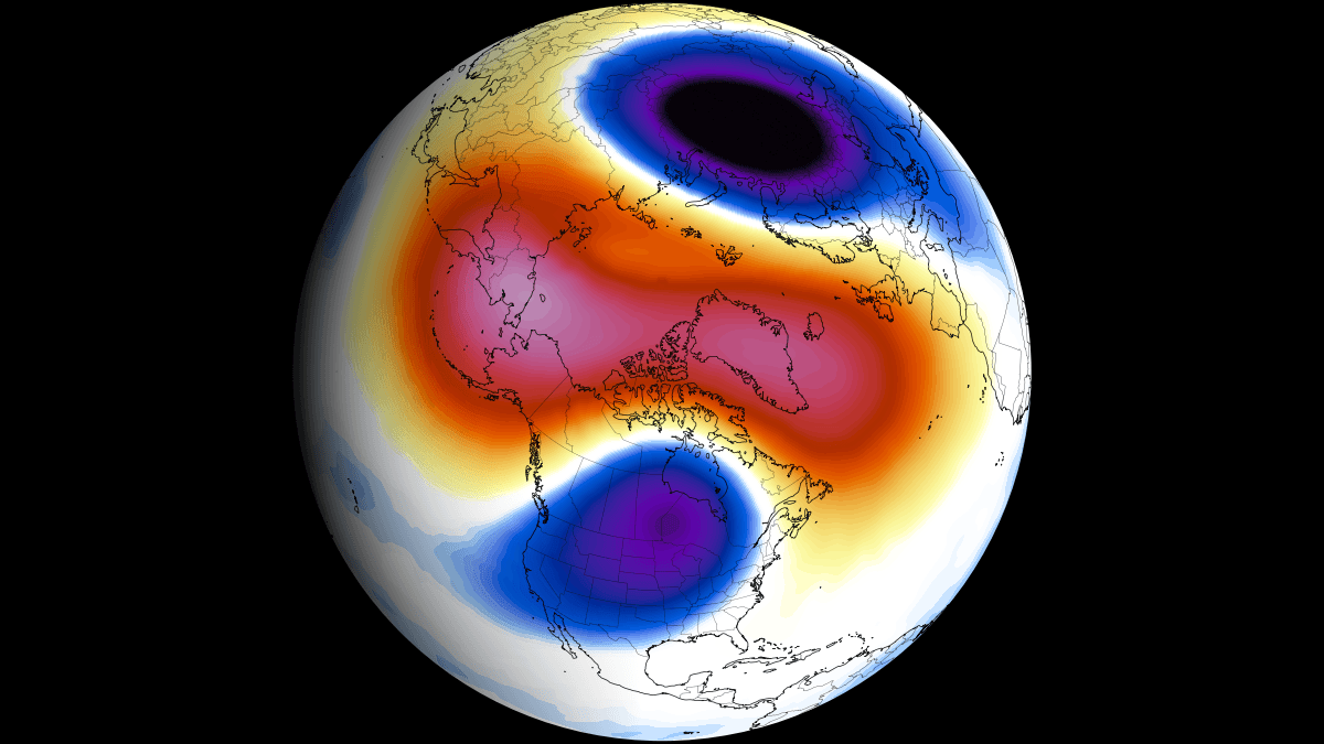
The polar vortex is a massive band of low pressure and freezing air circulating high in the stratosphere, generally between 15 and 50 kilometres above the polar regions. Under typical seasonal conditions, this circulation strengthens steadily throughout the autumn, peaking around January before subsiding in the spring. In early November 2026, global tracking systems recorded a rapid deceleration of mid-stratospheric winds at the 10-hectopascal level, approximately 30 kilometres above the surface.
Forecast models from the European Centre for Medium-Range Weather Forecasts and the Global Forecast System show these winds approaching a full reversal. Such a reversal defines a Sudden Stratospheric Warming event. If confirmed, this disturbance will occur at least 3 weeks earlier than any previously documented split, breaking the prior record date of November 28. Analysis of the ECMWF ensemble reveals a 96% chance of a wind reversal, while the GEFS model shows a 71% chance.
scientists had never observed a sudden stratospheric warming so early in the season.
The disturbance is driven by a massive pulse of atmospheric wave energy moving upward from the lower atmosphere. This wave has driven stratospheric temperatures almost 22°C (40°F) above normal, fracturing the vortex into two distinct cores centered over Eurasia and North America.
Is Climate Change a Factor?
Attribution research has not established a direct cause-and-effect link between global climate change and this specific, exceptionally early disruption. Atmospheric scientists acknowledge that changing polar conditions and sea-ice variations influence the behavior of the tropospheric jet stream, but pinning individual stratospheric warming events to broader warming patterns remains complex. The exact mechanism triggering this November event without precedent has not been disclosed by research teams.
Compounding the atmospheric puzzle is an active Super El Niño across the equatorial Pacific. Peak sea-surface temperature anomalies in eastern Pacific sectors have exceeded +8°C (+14.4°F) above normal. A tropical anomaly of this magnitude exerts heavy atmospheric forcing on northern weather systems, typically deepening the Aleutian Low over the North Pacific and altering the flow of energy into the polar cap.
- Sudden Stratospheric Warming
- A rapid temperature surge of tens of degrees Celsius within days in the polar stratosphere, which can stall or reverse westerly winds.
- Polar Vortex Core
- The dense pool of freezing low-pressure air circulating within the stratosphere that acts as a containment barrier over the Arctic.
- Arctic Oscillation
- A climate index tracking sea-level pressure differences between the Arctic and mid-latitudes, often turning negative following a stratospheric breakdown.
How Conditions Have Changed
Major disruptions of the polar vortex typically unfold between January and March, averaging roughly six major events per decade since systematic records began in 1958. Prior to this event, the only other recorded November disruptions emerged during late November in 1968 and 2025. Following both of those historical precedents, December brought colder-than-average conditions across sectors of North America, though snowfall in December 1968 remained under an inch in monitored eastern zones and December 2025 yielded no measurable snow in those same regions.
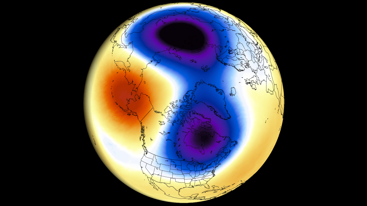
Historical data compiled from 34 major sudden stratospheric warming events indicates that when a complete collapse takes place during mid-winter, below-normal surface temperatures settle across Canada, the United States, and northern Europe in the following 0 to 30 days. However, because the seasonal cold pool over the Arctic is still underdeveloped in early November, the downstream surface consequences will behave differently from mid-winter collapses such as the January 2016 event.
Who Is Most Exposed
The downstream consequences of a stratospheric breakdown rarely strike uniformly. When high-altitude winds collapse, the high-pressure anomaly works its way down into the troposphere on a delayed schedule, typically taking 1 to 4 weeks to affect surface conditions. In the near term, dynamic modeling around day 7 and day 12 reveals an elongated low-pressure zone forming over eastern Canada.
This pressure distribution pulls modified air masses across the eastern provinces while steering cooler trends into parts of the eastern United States and Europe. If these fragmented lobes anchor over continental landmasses, commercial transit, energy networks, and early agricultural transport across central and eastern Canada face sudden shifts in baseline operating conditions. Conversely, western regions may encounter strong ridging influenced by the Pacific El Niño pattern, creating steep temperature contrasts across provinces.
Adaptation and Future Risk
Long-range seasonal modeling from the ECMWF indicates that this November disturbance is only the opening chapter of a volatile winter. Historical analogues from seasons combining similar ocean and atmospheric states — specifically 1957/58, 1982/83, 1997/98, and 2015/16 — demonstrate that strong Pacific warmth often re-energizes wave propagation as the season progresses.
Current projections indicate a secondary, potentially more pronounced stratospheric warming trend building from late December into February. Municipal infrastructure managers, provincial energy grids, and winter operations crews must account for elevated volatility. While an early November breakdown does not guarantee sustained freezing conditions in every province, it raises the baseline probability of rapid Arctic air outbreaks as the vortex barrier remains compromised.
Frequently Asked Questions
What is the polar vortex?
The polar vortex is a wide circulation of low pressure and freezing air spinning over the polar regions in the stratosphere. It sits between 15 and 50 kilometres high and acts as a barrier trapping dense cold air near the Arctic.
Why is this November polar vortex split considered historic?
Major stratospheric warmings and vortex collapses typically happen between January and March. This disruption is arriving in the first week of November, outpacing the earliest previous event on record by at least three weeks.
Does an early polar vortex collapse guarantee extreme cold across Canada?
No, a collapse does not guarantee extreme cold in every region. Surface effects depend on where the fragmented low-pressure cores settle, and disruptions take one to four weeks to migrate down to ground level.
How does El Niño affect the polar vortex this season?
A Super El Niño in the Pacific alters tropospheric jet streams and deepens the Aleutian Low. Over the course of the winter, this configuration pumps wave energy into the upper atmosphere, increasing the likelihood of further vortex breakdowns.