Perth Residents on High Alert as Cyclone Narelle Tracks Rare Path South: Trend Summary
The Bureau of Meteorology has issued urgent alerts as ex-tropical cyclone Narelle re-forms off the Western Australian coast, threatening to bring severe weather to Perth. The system is intensifying and moving on an unusual trajectory toward the state’s south-west, which is rarely impacted by such systems. Residents are being urged to prepare for a significant drenching and potential wind damage starting Tuesday night.
TL;DR
- Ex-tropical cyclone Narelle has re-formed and is intensifying off the WA coast.
- The system is following a "very unusual" path directly toward Perth and the South West.
- Severe weather warnings for heavy rainfall and damaging winds have been issued.
- The impact is expected to peak between late Tuesday, March 24, and Wednesday, March 25, 2026.
What Happened
On March 24, 2026, the Bureau of Meteorology confirmed that the remnants of ex-tropical cyclone Narelle had moved back over open waters, where warm sea surface temperatures allowed the system to re-intensify. Unlike most cyclones that track west or fizzle out before reaching southern latitudes, Narelle is moving almost directly south. Meteorologists described this movement as a bolt from the blue, as it is rare for a tropical system to maintain such strength while approaching Perth.
By Monday evening, the system began its "southward charge," with atmospheric models showing a high probability of a direct impact on the metropolitan area. The Bureau of Meteorology has placed the region from Geraldton down to Albany on alert. Emergency services have already begun staging equipment in high-risk zones, and authorities are warning that this "compact but dangerous" system could catch residents off guard.

Key Developments
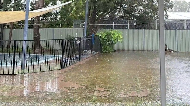
The system is currently categorized as a tropical cyclone and is expected to track approximately 200 kilometers offshore before making its closest approach to the capital. Rainfall totals could exceed 100mm in some isolated coastal areas within a 24-hour period. Wind gusts are forecast to reach up to 90km/h, which is high enough to bring down trees and power lines, especially given the dry state of the vegetation in the region.
The track this system is taking is very unusual. Usually, these systems weaken significantly before they get this far south, but Narelle is holding its structure.
Residents can monitor the latest movements and official warnings via the Bureau of Meteorology WA Warnings portal. It is critical that residents secure loose items around their homes before the winds arrive on Tuesday night.
Why This Matters
The unusual path of Narelle matters because the infrastructure in Perth and the South West is not frequently tested by tropical-strength weather systems. A direct hit or even a close brush could lead to widespread power outages and localized flooding. From a meteorological standpoint, this event is significant as it challenges standard seasonal patterns and highlights the impact of warmer-than-average ocean temperatures off the WA coast.
What Happens Next
The heaviest weather is expected to hit Perth and the Peel region through Wednesday morning. Once the system passes the South West Capes, it is expected to move further into the Southern Ocean and transition back into a cold-core low-pressure system by Thursday. Maintenance crews from Western Power are on standby to address any grid damage, and the Department of Fire and Emergency Services (DFES) will provide updates throughout the event.
Key Terms & Concepts
- Ex-tropical cyclone
- A former tropical cyclone that has lost its tropical characteristics but still maintains a low-pressure center and can produce dangerous winds and rain.
- Re-intensification
- The process where a weakening weather system gains strength again, often due to moving over warmer waters.
Frequently Asked Questions
When will Cyclone Narelle hit Perth?
The system is expected to bring its strongest winds and heaviest rain to Perth between late Tuesday night, March 24, and Wednesday afternoon, March 25.
Is there a flood warning for Perth?
Yes, the Bureau of Meteorology has flagged a high risk of localized flooding with rainfall totals potentially reaching 100mm in some areas.
How fast are the winds expected to be?
Wind gusts are forecast to reach up to 90km/h, which is strong enough to cause structural damage and uproot trees.
Is it rare for a cyclone to reach Perth?
It is very rare for a system to maintain tropical cyclone strength this far south; most systems dissipate or turn into standard rain-bearing lows before reaching the city.

Resources
Sources and references cited in this article.