Blizzard Warning Trend Summary: Heavy Snow and Dangerous Winds Trigger Travel Alerts Across Northern U.S.
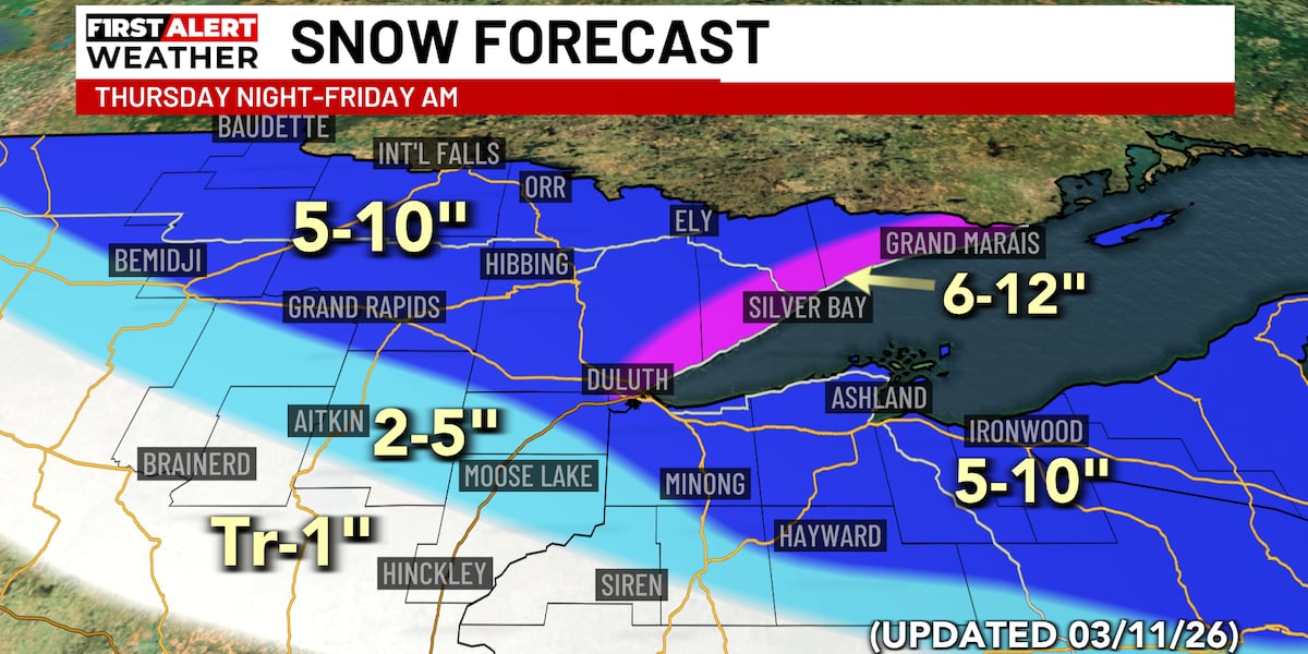
Blizzard warnings and winter storm alerts were issued across parts of the northern United States on Wednesday and Thursday as a powerful late-season storm system developed. The system is expected to bring heavy snowfall, strong winds, and near-zero visibility to regions including Minnesota, Wisconsin, and the Red River Valley. Forecasts warn that the most severe conditions will occur Thursday evening through Friday. Authorities say travel disruptions and hazardous road conditions are likely across affected areas.
The storm arrives as another winter system follows closely behind, extending the period of unsettled weather across the northern tier of the country. Meteorologists warn that strong winds combined with falling snow may create blizzard conditions in several counties. Communities are preparing for difficult travel and rapidly changing weather conditions through the end of the week.
TL;DR
- Blizzard and winter storm warnings issued across parts of the northern United States.
- Heavy snow and strong winds expected to intensify Thursday evening through Friday.
- Travel conditions may become dangerous due to blowing snow and low visibility.
- Back-to-back winter storms could extend disruptive weather into the weekend.
What Happened
Weather agencies issued blizzard and winter storm warnings as a major winter system approached northern states late in the week. Forecast models indicate periods of heavy snowfall beginning Wednesday night and intensifying Thursday evening across areas including northern Minnesota, Wisconsin, and the Red River Valley region.
Strong winds accompanying the storm are expected to produce blowing snow and drastically reduced visibility. Meteorologists warned that snowfall combined with gusty winds could create full blizzard conditions in some locations, especially across open areas and highways.
Officials in several counties advised residents to prepare for rapidly deteriorating travel conditions. Snow accumulation, drifting snow, and icy roads may lead to dangerous driving and possible road closures in affected regions.
The storm system is part of a broader weather pattern moving across the northern United States, bringing waves of precipitation and colder air late in the week.
Key Developments
Forecast updates indicate that the strongest impacts are expected Thursday evening through Friday as wind speeds increase and snowfall intensifies. Weather models suggest that several areas may experience prolonged periods of heavy snow.
Warnings have been issued for multiple counties in Minnesota and Wisconsin where blizzard conditions are considered possible. These warnings highlight the risk of strong winds lifting and blowing snow, creating hazardous visibility levels.
Travel experts also warned that winter storms could significantly affect regional transportation. Drivers may encounter snow-covered highways, drifting snow, and rapidly changing road conditions.
Another winter system is expected to follow the initial storm later in the weekend, bringing additional snow and mixed precipitation to parts of the northern region.
Why This Matters
Blizzard warnings indicate the potential for extremely dangerous winter weather that can disrupt transportation and daily activities. When strong winds combine with falling or blowing snow, visibility can fall below safe driving levels.
Communities across the northern United States rely heavily on road travel, making severe winter weather a major operational challenge. Snow accumulation and drifting can also impact local infrastructure, emergency services, and regional travel routes.
Back-to-back storm systems also extend the duration of hazardous conditions, increasing the likelihood of travel delays and weather-related disruptions across the affected states.
What Happens Next
The primary winter storm is expected to move through the region Thursday evening and Friday, producing the most intense snowfall and wind conditions during that period.
Forecasters indicate that additional snow showers and mixed precipitation could continue into the weekend as another weather system approaches the northern United States.
Local authorities will continue monitoring road conditions and issuing updates as snowfall accumulates and winds increase across the impacted areas.
Key Terms & Concepts
- Blizzard Warning
- An official weather alert issued when heavy snow and strong winds are expected to cause visibility of less than one quarter mile for several hours.
- Blowing Snow
- Snow lifted from the ground by strong winds, which can significantly reduce visibility even when snowfall is light.
- Winter Storm System
- A large atmospheric disturbance that produces snow, wind, and cold temperatures across a wide region.
Frequently Asked Questions
What areas are affected by the blizzard warning?
Warnings were issued for parts of the northern United States, including counties in Minnesota, Wisconsin, and the Red River Valley region.
When will the storm bring the worst conditions?
Forecasters expect the most severe weather to occur Thursday evening through Friday as heavy snow and strong winds intensify.
Why is travel expected to be dangerous?
Blowing snow and wind gusts can reduce visibility to near zero, while accumulating snow and ice make highways difficult to drive.
Will the winter weather continue after the first storm?
Yes. Forecasts indicate another winter system may arrive during the weekend, bringing additional snowfall to northern regions.
What does a blizzard warning mean?
A blizzard warning signals that heavy snow and strong winds are expected to create visibility below one quarter mile for an extended period.