Montreal Drivers Launch Interactive Map to Combat Rising Pothole Damage: A Trend Summary
Montreal motorists are utilizing a new community-driven interactive map created by Pierre-Olivier Gagné to track and report severe road hazards across the city this March 2026. The digital tool arrives as the city enters a particularly aggressive pothole season, characterized by a significant spike in vehicle repair claims. This grassroots initiative aims to provide real-time navigation support to prevent costly mechanical failures caused by deteriorating infrastructure.

TL;DR
- Montrealer Pierre-Olivier Gagné launched an interactive map to track city-wide potholes.
- Pothole-related vehicle damage has increased by nearly 50% according to CAA reports.
- Drivers are using the tool to crowdsource road hazard locations in real-time.
- The initiative seeks to reduce repair costs and pressure municipal authorities for faster maintenance.
What Happened
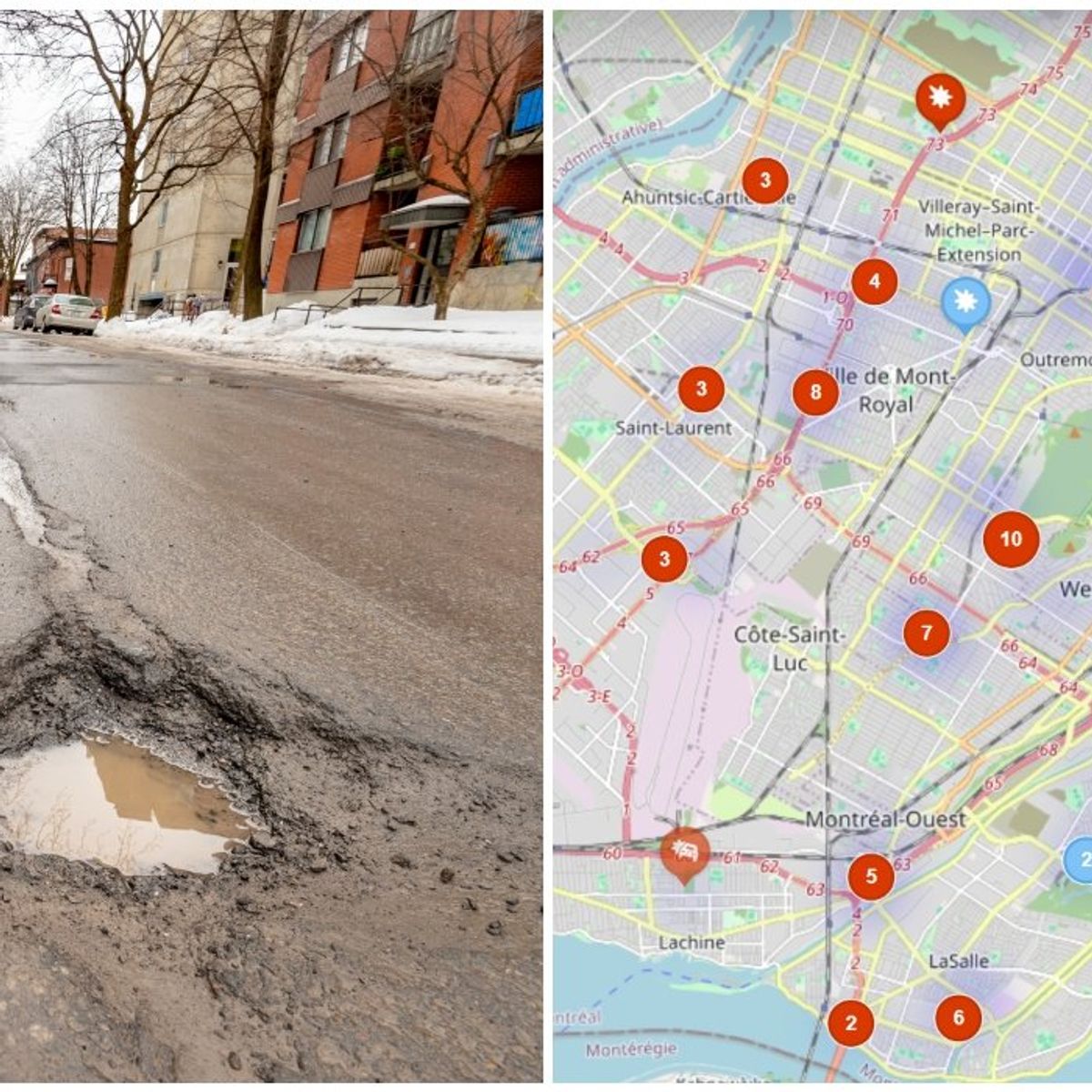
In response to a surge in road hazards, Montreal resident Pierre-Olivier Gagné developed and launched a specialized interactive map designed to catalog the location and severity of potholes throughout the metropolitan area. The platform allows users to pin specific locations where road degradation is present, helping fellow commuters adjust their routes to avoid damage. This surge in civic tech usage follows a report from CAA-Quebec indicating that claims for pothole-related vehicle damage in Montreal have risen by nearly 50% compared to previous years. The worsening road conditions are attributed to volatile freeze-thaw cycles that have accelerated the breakdown of asphalt across major arteries and residential streets alike.
Key Developments
The new digital interface, often referred to by locals as the Ayoye map, provides a visual heat map of Montreal's most neglected sectors. Drivers can access the interactive road conditions portal to report new craters or verify if a reported hazard has been patched. Recent data integrated into these discussions highlights that the average cost of a suspension or tire rim repair caused by a deep pothole can now exceed $500 to $1,000 depending on the vehicle model. Furthermore, municipal crews have reportedly increased their asphalt production to meet the demand, yet the backlog of citizen reports on the 311 service line continues to grow, prompting many to turn to this unofficial third-party tool for immediate updates.
Pothole season is here but Montreal drivers are fighting back with this new interactive tool that reshapes how we navigate our streets.
Why This Matters
The state of Montreal’s roads has a direct economic impact on thousands of residents, with insurance companies reporting a record-breaking volume of claims this season. For the city, the visibility of the interactive map puts measurable pressure on the administration to prioritize high-traffic zones that are flagged most frequently by the community. On a broader scale, the 50% increase in damage reported by CAA suggests that current infrastructure maintenance cycles are failing to keep pace with environmental stressors, potentially leading to higher insurance premiums for all Quebec drivers in the long term.
What Happens Next
Montreal's public works departments are expected to deploy additional 'pothole-filling' units throughout the spring months as temperatures stabilize. The interactive map is scheduled to receive technical updates to allow for photo uploads, providing visual proof of hazard size for insurance purposes. Drivers are encouraged to continue reporting through official channels while using the map for daily navigation until major repaving projects begin in the summer of 2026.
Frequently Asked Questions
What is the new Montreal pothole map?
It is a community-driven interactive tool created by Pierre-Olivier Gagné that allows drivers to report and track road hazards in real-time. The map helps motorists avoid areas with severe asphalt damage to prevent vehicle repairs.
Why has pothole damage increased by 50% in Montreal?
According to CAA, the 50% increase in damage is due to severe weather patterns and aging infrastructure. Frequent freeze-thaw cycles cause water to expand in road cracks, leading to more frequent and deeper potholes.
How can I report a pothole using the interactive tool?
Users can visit the official web portal to drop a pin on the exact location of the hazard. While this is a private initiative, it serves as a supplement to the city's official 311 reporting system.
Is the city of Montreal responsible for pothole damage?
While the city is responsible for road maintenance, claiming compensation for damage is often difficult and requires proving municipal negligence. Most drivers are currently relying on the new map to avoid hazards entirely rather than seeking legal recourse.