
Pittsburgh Severe Storms and Drastic Temperature Swings: A Weekly Trend Summary
The Pittsburgh region and Western Pennsylvania are facing a period of severe weather and volatile temperature fluctuations starting Wednesday, March 11, 2026. A powerful cold front is moving through the area, bringing threats of damaging winds, heavy rain, and isolated tornadoes. This weather system marks a sharp transition from unseasonal warmth back to late-winter conditions.
TL;DR
- Severe thunderstorms and high winds are impacting Pittsburgh this Wednesday.
- The Storm Prediction Center has placed the region under a slight risk for severe weather.
- Temperatures are expected to plummet by nearly 30 degrees following the frontal passage.
- Potential for isolated tornadoes and damaging wind gusts up to 60 mph exists through the evening.
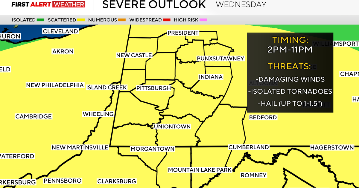
What Happened
A significant weather system began moving into the Pittsburgh metropolitan area and surrounding counties on Wednesday morning. The Storm Prediction Center (SPC) officially designated the region at a Level 2 out of 5 slight risk for severe thunderstorms. This development follows a period of mild temperatures that provided the energy necessary for atmospheric instability. By Wednesday afternoon, waves of heavy rain and gusty winds began crossing the Ohio Valley, moving directly into Western Pennsylvania. Local authorities reported that the primary threats included localized flooding and wind damage to power lines and trees.
Key Developments
Meteorologists have confirmed that the storm system is moving in distinct waves, with the most intense activity scheduled for late Wednesday afternoon and early evening. Wind gusts are projected to reach between 40 and 60 mph in the most severe cells. Rainfall totals are expected to average between 0.5 and 1 inch, though higher amounts are possible in areas seeing repeated downpours. The threat of an isolated tornado remains a concern for the Philadelphia and Pittsburgh regions as the cold front interacts with the lingering warm air mass. High temperatures on Wednesday reached the mid-60s, but will not remain at that level for long.
Why This Matters
This weather event is significant due to the extreme temperature gradient associated with the cold front. The rapid shift from spring-like warmth to freezing conditions creates hazardous driving conditions and puts stress on local infrastructure. For residents, this serves as a reminder that winter weather patterns persist well into March. The high wind threats also increase the likelihood of regional power outages and property damage, requiring heightened vigilance from emergency services and utility companies.
What Happens Next
Following the passage of the storm tonight, temperatures are forecast to drop sharply. By Thursday morning, lows will dip into the upper 20s or low 30s, representing a massive decrease from Wednesday's highs. Calm but much cooler conditions will persist through the remainder of the work week. Residents should monitor the National Weather Service Storm Prediction Center for real-time watches and warnings. All loose outdoor items should be secured immediately to prevent damage from high winds.
Key Terms & Concepts
- Slight Risk
- A Level 2 category used by the SPC indicating that scattered severe storms are possible, but they are not expected to be widespread.
- Cold Front
- The leading edge of a cooler mass of air that replaces a warmer mass of air, often triggering precipitation and storms.
Frequently Asked Questions
Is there a tornado warning for Pittsburgh right now?
As of Wednesday, the region is under a slight risk, meaning isolated tornadoes are possible but not guaranteed. Residents should stay tuned to local broadcasts for immediate warnings if rotation is detected on radar.
How much will the temperature drop in Pittsburgh?
Temperatures are expected to fall from highs in the 60s on Wednesday to lows in the 20s by Thursday morning. This is a total drop of approximately 30 to 40 degrees within 12 hours.
What time will the worst storms hit?
The most severe weather is expected to hit the Pittsburgh area in waves during the late afternoon and early evening hours of Wednesday. The activity should taper off as the cold front moves east by midnight.
Will there be snow in Pittsburgh this week?
While the immediate threat is rain and storms, the cold air following the front will bring temperatures below freezing. While significant accumulation is not currently forecast, light flurries are possible late Thursday.