Severe Storms and Large Hail Hit the Mid-Atlantic: Trend Summary
A powerful storm system moved across Virginia and Maryland on Monday, March 16, 2026, bringing threats of large hail, damaging winds, and tornadoes. Local authorities issued multiple warnings as fast-moving cells triggered a rare moderate risk level for the region. The severe weather disrupted daily activities and prompted immediate safety alerts for millions of residents in the DMV area.

TL;DR
- Large hail and damaging winds impacted Virginia and Maryland on Monday.
- Meteorologists issued Tornado Warnings and a rare Moderate Risk alert for the DMV.
- Storms moved at high speeds, creating sudden hazardous conditions for travelers.
- The event marks a significant early-season severe weather outbreak for the Mid-Atlantic.
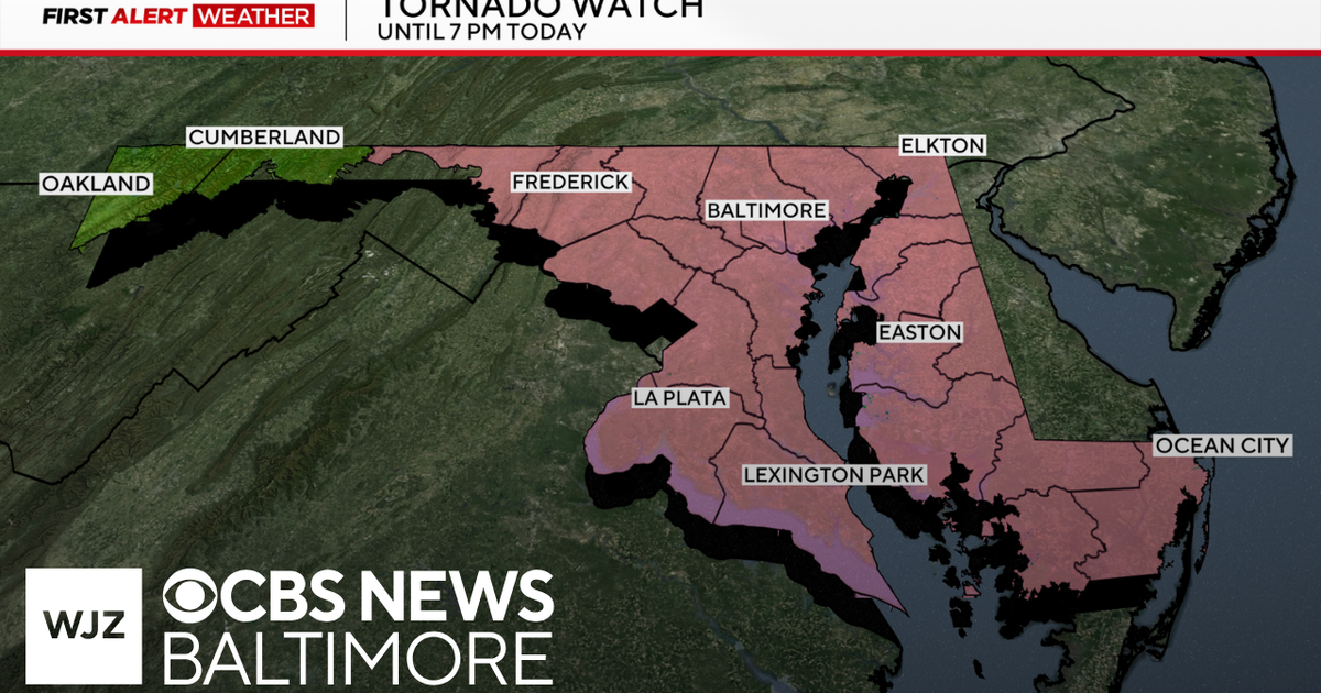
What Happened
On Monday, March 16, 2026, a high-velocity weather system swept through the Mid-Atlantic, specifically targeting Virginia, Maryland, and the District of Columbia. The National Weather Service elevated the threat level to a Level 4 out of 5 (Moderate Risk), a designation rarely seen in this region. Fast-moving storms began producing large hail and wind gusts exceeding 60 mph by midday. In Maryland, rapid-response Tornado Warnings were triggered as radar indicated rotation within the storm line, forcing residents to seek immediate shelter. The Shore region also experienced intense activity with damaging winds reported shortly after the main front passed through the central metropolitan areas.
Key Developments
The Storm Prediction Center highlighted that the atmospheric conditions were uniquely primed for significant severe weather. Forecasts indicated that the storms could produce multiple tornadoes, some of which had the potential to be long-tracked. Meteorologists, including Sean Sublette, provided real-time updates as the line of storms transitioned from the Blue Ridge Mountains toward the coast. Detailed weather forecast videos were released to help the public track the exact timing of the hail impact. On the Eastern Shore, the primary concern shifted toward damaging straight-line winds that threatened power infrastructure and coastal property. Emergency management agencies advised citizens that staying indoors and away from windows was the most critical action during the height of the storm.
Why This Matters
The issuance of a moderate risk alert is a critical indicator of high-impact weather that can cause widespread property damage and pose a threat to life. The prevalence of large hail is particularly concerning for the region's vehicles and residential roofing. Furthermore, the timing of these storms during the Monday commute increased the risk for motorists caught on open highways. The shift in weather patterns suggests a more active and volatile spring season for the Eastern Seaboard. Residents are urged to monitor local alerts via mobile devices to receive instantaneous updates on moving cells.

What Happens Next
As the cold front moves offshore late Monday night, temperatures are expected to drop significantly. Post-storm damage assessments will begin on Tuesday morning to evaluate the extent of hail damage and potential tornado touchdowns. Utility crews remain on standby to restore power to areas affected by downed trees and lines. No further severe outbreaks are confirmed for the immediate remainder of the week, though unstable air may linger in the coastal regions through Tuesday afternoon.
Key Terms & Concepts
- Moderate Risk
- The fourth level on the five-level scale used by the SPC, indicating a high potential for widespread and intense severe weather.
- DMV
- A common abbreviation for the metropolitan area consisting of the District of Columbia, Maryland, and Virginia.
- Rotation
- A radar-indicated pattern suggesting the potential formation of a tornado within a thunderstorm.
Frequently Asked Questions
What was the severe weather risk level on Monday?
The region was placed under a rare Moderate Risk, which is Level 4 out of 5 on the National Weather Service's scale. This alert indicated a high likelihood of intense storms on March 16.
Were there any tornadoes in Maryland?
Multiple Tornado Warnings were issued in Maryland on Monday due to fast-moving storms. Radar indicated rotation in several cells, prompting residents to take cover immediately.
What kind of damage was expected from the storms?
Authorities warned of large hail, damaging winds exceeding 60 mph, and the potential for tornadoes. These conditions are capable of damaging roofs, vehicles, and power lines.
How fast were the storms moving across Virginia?
The storms were characterized as fast-moving, which meant conditions deteriorated rapidly within minutes. This made it essential for residents to have a way to receive alerts instantly.
Where can I see the latest weather updates for the DMV?
Local meteorologists like Sean Sublette and stations such as WJLA and WTVR provided continuous live coverage. You can access the official weather blog for real-time tracking.
Resources
Sources and references cited in this article.