Tropical Cyclone Narelle Forecast and Severe Weather Trend Summary
Ex-Tropical Cyclone Narelle is forecast to re-develop off the Western Australian coast on Tuesday, March 24, 2026, after previously impacting Queensland as a Category 4 system. The Bureau of Meteorology has placed Perth and the South West on high alert as the system intensifies and tracks southward. Residents are advised to prepare for a significant drenching and potential destructive winds as the storm undergoes a rare secondary intensification.
TL;DR
- Ex-Tropical Cyclone Narelle is expected to reform into a tropical cyclone on Tuesday night.
- Perth and Western Australia’s South West face a high risk of heavy rainfall and flash flooding.
- The system was previously a Category 4 storm that impacted the Queensland coastline.
- Authorities warn of a rare southward charge that could bring cyclone-strength impacts to major metropolitan areas.
What Happened
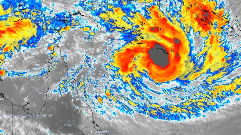
Ex-Tropical Cyclone Narelle, which recently crossed the Queensland coast and caused widespread disruption, has moved across the continent and is now gathering strength over the warm waters off the Western Australian coast. On March 24, 2026, meteorologists confirmed the system is likely to re-attain tropical cyclone status by tonight. This second life for the storm comes after police and SES crews spent the previous day supporting impacted communities in Queensland following its initial passage as a Category 4 system. Lightning never strikes twice in the same place, but for Narelle, this second intensification represents a double threat to the Australian coastline within a single week.
Cyclone Narelle is a compact, dangerous, and unusually predictable system that is now taking a rare southward charge toward our most populated areas.
Key Developments
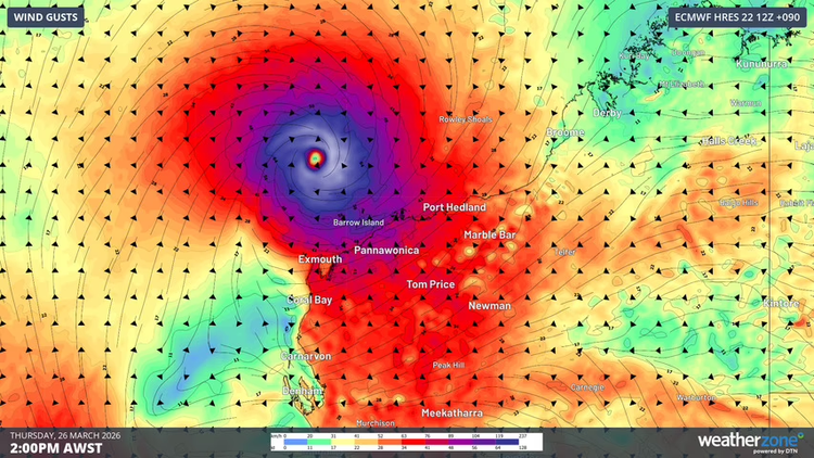
The Bureau of Meteorology (BoM) has updated its modeling to show a possible direct impact on Perth, a rare occurrence for tropical systems that typically weaken before reaching such high latitudes. Current forecasts indicate a high chance of the storm intensifying offshore before it accelerates toward the south. Emergency services in Western Australia have begun pre-positioning resources, following the successful cleanup operations led by Queensland Police and the SES in the Far North. Updates on weather warnings and emergency instructions can be found at the BoM official weather portal.
Why This Matters
The southward trajectory of Narelle is significant because it brings severe weather to regions often unprepared for tropical cyclone intensity. The potential for heavy drenching and high winds in Perth could disrupt major infrastructure, transport, and power grids. Furthermore, the re-intensification of an ex-tropical cyclone after crossing land is a meteorologically significant event that highlights the current volatility of sea surface temperatures in the region. The impact on local agriculture and water catchments in the South West will be substantial, with rainfall totals expected to exceed monthly averages in just 24 to 48 hours.
What Happens Next
The system is expected to reach its peak intensity offshore on Wednesday, March 25, 2026, before its closest approach to the coast. Residents from Geraldton down to Albany should monitor local radio and official alerts for evacuation orders or severe weather warnings. The most critical period for Perth is expected to be between Wednesday evening and Thursday morning. Recovery efforts in Queensland will continue in parallel as Western Australian authorities pivot to full emergency response mode.
Key Terms & Concepts
- Category 4
- A severe tropical cyclone with typical gust speeds of 225–279 km/h, capable of causing significant structural damage.
- Ex-Tropical Cyclone
- A system that has lost its tropical characteristics but still maintains a deep low-pressure center and can produce dangerous weather.
- Southward Charge
- A movement where a cyclone tracks toward higher latitudes (south in the Southern Hemisphere), often increasing the risk to temperate regions.
Frequently Asked Questions
When will Cyclone Narelle hit Perth?
Current BoM models suggest the most significant weather impacts, including heavy rain and wind, will reach Perth between late Wednesday, March 25, and early Thursday, March 26. The system is expected to remain offshore but close enough to cause severe conditions.
How strong was Cyclone Narelle when it hit Queensland?
Narelle reached Category 4 status as it approached the Queensland coastline earlier this week. It caused significant damage in the Far North before weakening into an ex-tropical cyclone as it moved inland.
Is it common for cyclones to reach Perth?
No, it is relatively rare for tropical cyclones to maintain strength this far south. Narelle is taking an unusual path that brings it into the South West region, prompting high-level alerts for the metropolitan area.
What should residents do to prepare?
Residents should clear gutters, secure loose outdoor items, and prepare an emergency kit. High-value actionable updates and emergency checklists are available through the SES and official government portals.
Will there be flooding in Western Australia?
Yes, the forecast predicts a "drenching" for the South West, with heavy rainfall likely to lead to flash flooding in low-lying areas and significant rises in local river levels through Friday.

Resources
Sources and references cited in this article.