Byron Bay and Northern Rivers Flash Flooding: Trend Summary
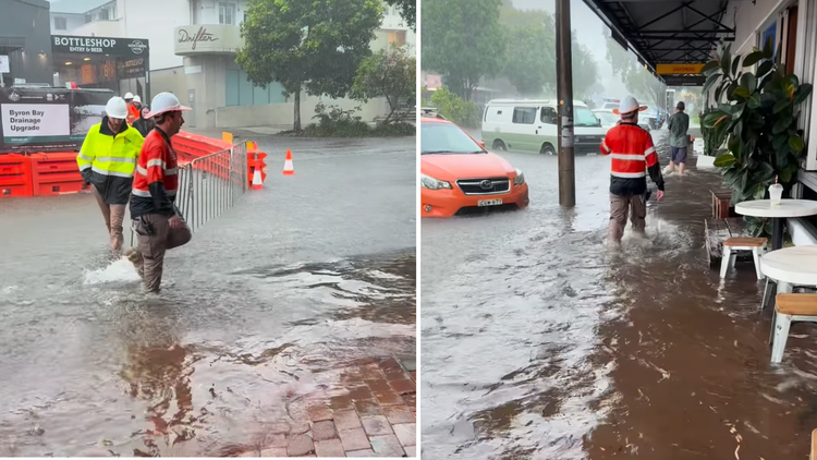
Flash flooding struck Byron Bay and the surrounding Northern Rivers region on Friday, March 13, 2026, following an extraordinary deluge that dropped nearly a meter of rain in just four hours. Emergency services performed multiple rescues as rising waters inundated roads, homes, and public spaces in towns like Bangalow and Byron Bay. The region remains on high alert as severe storms continue to track across northern New South Wales and southeast Queensland.

TL;DR
- Emergency services rescued 3 people trapped in floodwaters in Bangalow.
- A record-breaking 1 meter of rain fell in a 4-hour period in localized spots.
- Significant property and vehicle damage reported across Byron Bay and the Northern Rivers.
- Severe weather warnings remain active for northern NSW and southeast Queensland.
What Happened
The weather event intensified rapidly on Friday morning when a slow-moving storm system stalled over the Byron Shire. In the town of Bangalow, the intensity reached extreme levels as approximately 1,000mm of rain fell within a single four-hour window, leading to immediate and life-threatening flash flooding. Roads quickly became impassable, trapping motorists and residents in their homes as local creeks broke their banks.
The New South Wales State Emergency Service (SES) responded to dozens of calls for assistance throughout the morning. In Bangalow, 3 individuals were successfully rescued from floodwaters after their vehicles became submerged. Local schools and public facilities, including the Bangalow Showground, were severely affected, with dozens of cars left underwater as the surge caught many by surprise.
Key Developments
The Bureau of Meteorology has confirmed that this event is part of a broader pattern of abnormal humidity and severe storm activity affecting the Australian east coast. While Byron Bay and Bangalow took the brunt of the flash flooding, the system has also triggered severe thunderstorm warnings for parts of southeast Queensland and the Sydney metropolitan area. Residents in affected zones are advised to monitor the latest NSW severe weather warnings for real-time updates.
The amount of water that fell in such a short period is simply unprecedented for this specific catchment, leaving residents with almost no time to react.
Why This Matters
This flash flood has immediate implications for regional infrastructure and safety. The 1 meter rainfall mark represents a significant meteorological anomaly that has overwhelmed drainage systems designed for standard tropical bursts. Beyond the immediate damage to personal property and vehicles, the event highlights the extreme volatility of the current autumn weather transition, characterized by record-high humidity levels across the state. The saturation of the ground means that any subsequent rainfall, even in smaller amounts, now poses a high risk of further flooding.
What Happens Next
Emergency crews are currently conducting damage assessments and cleaning up debris as water levels begin to recede in some areas. However, residents are told to stay indoors and avoid all non-essential travel while the storm cell remains active in the region. The Bureau of Meteorology expects the unstable weather to persist throughout the weekend, with further heavy falls predicted for northern NSW and the Illawarra region. Local councils will begin assessing the structural integrity of flooded bridges and roads once conditions stabilize.
Frequently Asked Questions
How much rain fell in Byron Bay today?
Localized areas in the Byron Shire, specifically around Bangalow, recorded nearly 1 meter (1,000mm) of rain within a 4-hour period on March 13, 2026.
Were there any casualties in the Byron Bay floods?
No fatalities have been reported, but emergency services successfully rescued 3 people from floodwaters in the Bangalow area who were trapped in their vehicles.
Is it safe to drive to Byron Bay right now?
Authorities have advised residents and travelers to stay indoors and avoid the area if possible, as flash flooding has damaged several roads and left others submerged.
Why was the rainfall so intense in Northern NSW?
The intense rainfall was caused by a slow-moving storm cell fueled by abnormal humidity levels and high sea-surface temperatures, which stalled over the Northern Rivers region.