Tropical Cyclone Narelle Forms in Coral Sea: Queensland Trend Summary
Tropical Cyclone Narelle officially formed in the Coral Sea off the Far North Queensland coast on Tuesday, March 17, 2026. The system is currently intensifying and tracking toward the Australian mainland, prompting widespread weather warnings for coastal communities. Authorities are bracing for a significant impact as the storm is forecast to strengthen further before making landfall within the coming days.
TL;DR
- Tropical Cyclone Narelle has officially formed off the Far North Queensland coast.
- The Bureau of Meteorology has issued primary alerts for coastal towns between Cooktown and Townsville.
- The system is expected to intensify to a Category 3 or 4 severe tropical cyclone.
- Heavy rainfall, damaging winds, and flash flooding are imminent for vulnerable zones.
What Happened
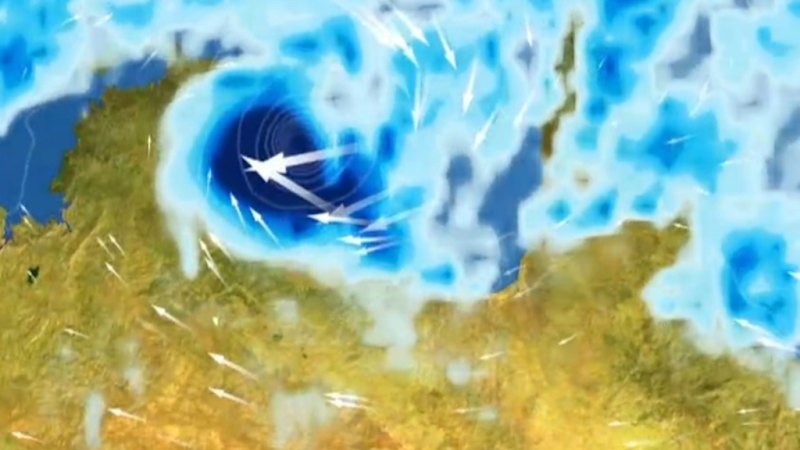
On March 17, 2026, the Bureau of Meteorology (BoM) upgraded a tropical low, previously designated as 34U, to Tropical Cyclone Narelle. The system is currently located several hundred kilometers off the Far North Queensland coast and is moving in a south-westerly direction. This development follows a period of high sea-surface temperatures in the Coral Sea, which provided the necessary energy for the low-pressure system to organize into a named cyclone.
Residents in the path of the storm can monitor the progress through the official Cyclone Narelle live tracker for real-time updates. Emergency services have begun pre-positioning resources in Cairns and surrounding districts. Flood warnings have already been issued for thousands of residents in low-lying areas that are still recovering from previous wet season events.
Key Developments
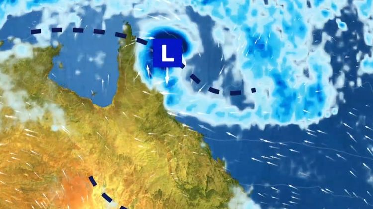
Forecasters have noted that Narelle is entering an environment favorable for rapid intensification. Current models suggest the system could reach Category 3 status by Wednesday and potentially Category 4 before crossing the coast. Sustained winds near the center are expected to exceed 120km/h, with gusts possibly reaching 200km/h in the most intense quadrants.
The Bureau of Meteorology has released a severe weather video update detailing the expected timing of coastal impacts. Coastal crossing is currently estimated to occur late Thursday or early Friday between Port Douglas and Lucinda. Total rainfall amounts could exceed 300mm in localized areas within a 24-hour period, leading to life-threatening flash flooding.
This is a significant system with the potential for severe damage to infrastructure and property. Communities in the warning zone must finalize their preparations immediately.
Why This Matters
The arrival of a Category 4 cyclone would be the most significant weather event for the region this season. Beyond the immediate threat to life and property, the storm poses a major risk to the Great Barrier Reef and regional agriculture, particularly sugarcane and banana crops. Heavy surges are also expected to impact shipping lanes and coastal infrastructure. The saturation of existing catchments means that even moderate rainfall from the outer bands could trigger significant riverine flooding across the Far North.
What Happens Next
The BoM will continue to issue three-hourly track updates as the system approaches the coast. Residents are urged to secure loose items and prepare emergency kits. The deadline for completing household preparations in Far North Queensland is Wednesday evening, before gale-force winds are expected to reach the coastline. Local disaster management groups are meeting frequently to determine if mandatory evacuations will be required for storm-tide zones.
Key Terms & Concepts
- Category 4 Cyclone
- A severe tropical cyclone with top gusts of 225–279 km/h, capable of causing significant roofing loss and widespread power failure.
- Tropical Low
- An area of low atmospheric pressure that can develop into a cyclone if conditions like warm sea temperatures and low wind shear are met.
- Storm Tide
- The rise in sea level that occurs during a tropical cyclone, caused by strong winds pushing water toward the shore and low atmospheric pressure.
Frequently Asked Questions
What is the current status of Cyclone Narelle?
As of March 17, 2026, Narelle has been officially declared a tropical cyclone and is intensifying in the Coral Sea. It is expected to strengthen into a severe Category 3 or 4 storm before making landfall.
Where is Cyclone Narelle expected to hit?
Current forecasts suggest the cyclone will cross the Far North Queensland coast between Cooktown and Townsville. Cairns and Port Douglas are currently within the high-impact zone.
When will the cyclone reach the Queensland coast?
The system is projected to make landfall late on Thursday, March 19, or early Friday, March 20. Gale-force winds may be felt along the coast as early as Wednesday night.
How strong will Tropical Cyclone Narelle be?
The Bureau of Meteorology predicts it will become a severe tropical cyclone, potentially reaching Category 4 with wind gusts exceeding 200km/h. Heavy rainfall and flooding are also major concerns.
Is there a live map to track Cyclone Narelle?
Yes, the public can access a live tracking map through the ABC News website to monitor the coordinates and projected path of the storm in real-time.
Resources
Sources and references cited in this article.