
Ontario and Quebec Severe Winter Weather Alert: March 2026 Storm Trend Summary
Environment Canada and local authorities issued a series of critical weather warnings across Ontario and Quebec starting March 10, 2026, as a massive storm system brought a dangerous mix of freezing rain, heavy rainfall, and unseasonal thunderstorms. The weather event has triggered widespread school closures in Montreal and raised significant flood risks in southern Ontario. Rapidly changing conditions are currently impacting travel and public safety across the corridor from London to Quebec City.
TL;DR
- Severe freezing rain and heavy rainfall are hitting major hubs in Ontario and Quebec.
- Pre-emptive school closures have been enacted across Montreal and parts of Quebec.
- Flood warnings are active for Toronto and London due to rainfall totals reaching 40 mm.
- The storm creates high risks for power outages and hazardous travel conditions.
What Happened
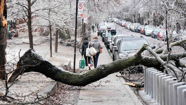
On March 10 and 11, 2026, a powerful weather system moved across Eastern Canada, resulting in Environment Canada issuing a 'potentially critical' freezing rain warning for Quebec and rainfall warnings for southern Ontario. In Toronto, the storm arrived alongside record-breaking warmth, followed immediately by heavy downpours and thunderstorms. Simultaneously, the region from Ottawa to Quebec City began experiencing a sustained period of freezing rain, leading to ice accumulation on trees and power lines.
As the ice storm intensified, school boards in Montreal and surrounding areas began pre-emptively closing facilities to ensure student safety. In southern Ontario, including London and the Greater Toronto Area, the primary threat shifted to flash flooding as heavy rain fell on partially frozen ground, limiting the earth's ability to absorb excess moisture.
Key Developments
The Weather Network and Environment Canada confirmed that rainfall totals in Toronto are expected to reach up to 40 mm, accompanied by rare March thunderstorms. In Montreal, the transition to freezing rain has already caused several major school boards to cancel classes for the day. Officials warned that ice buildup could lead to significant utility failures.
Environment Canada warns of a potentially critical freezing rain event for Quebec that could impact infrastructure and travel.
In British Columbia, the same broader weather pattern has resulted in heavy snow forecasts, while Ontario continues to brace for shifting conditions. Residents can monitor local updates and report outages via their respective utility provider portals during the storm.
Why This Matters
This weather event is particularly significant due to the record-breaking temperatures recorded in Toronto just prior to the rain, which has created volatile atmospheric conditions. The volume of rain increases the risk of flash flooding in urban areas where drainage systems may still be impacted by winter debris. For Quebec, the ice storm poses a direct threat to the power grid, as even a few millimeters of ice can cause tree branches to snap and bring down electrical wires, leading to prolonged blackouts.
What Happens Next
Meteorologists expect the rainfall to taper off in southern Ontario by late March 11, though flood watches will remain in effect through the evening. In Quebec, the freezing rain is projected to continue through the night before transitioning to lighter flurries. Authorities will provide updates on school reopenings by 6:00 AM the following morning. Residents are urged to avoid non-essential travel until road salt and sand crews can clear the ice accumulation.
Frequently Asked Questions
Why are schools closed in Montreal today?
Schools are closed due to a severe freezing rain warning issued by Environment Canada on March 10, 2026. Authorities closed the buildings pre-emptively to prevent students and staff from traveling during high-risk icing conditions that make roads and sidewalks extremely dangerous.
How much rain is expected in Toronto?
Toronto is expected to receive up to 40 mm of rain during this storm event. This heavy volume has triggered rainfall warnings and concerns regarding flash floods in the Greater Toronto Area.
Is there a risk of power outages in Quebec?
Yes, there is a high risk of power outages in the corridor from Ottawa to Quebec City due to ice accumulation. Environment Canada has labeled the freezing rain event as 'potentially critical' because ice weight can easily damage power lines and infrastructure.
What is causing the flash flood risk in southern Ontario?
The flash flood risk in cities like London and Toronto is caused by heavy rainfall and thunderstorms falling on ground that is still partially frozen or saturated. This prevents the water from soaking into the soil, forcing it into streets and basements.
When will the freezing rain storm end?
The current weather models suggest the freezing rain will transition to flurries or stop by the early hours of March 12, 2026. However, residents should check local forecasts for specific timing in their municipality as the system moves east.