U.S. Extreme Weather Alert: Central and Eastern Regions Face Blizzards and Severe Storms Trend Summary
A massive weather system is currently battering the United States, bringing a historic blizzard to the Midwest and severe storm outbreaks across the East Coast and South on March 17, 2026. Millions of residents are under active winter weather warnings as heavy snow, high winds, and tornadoes disrupt travel and daily life. The immediate impact includes widespread power outages, grounded flights, and dangerous road conditions from Green Bay to the Atlantic seaboard.

TL;DR
- Historic blizzard conditions are paralyzing the Midwest, specifically Wisconsin and Michigan.
- A rare severe storm outbreak is targeting the East Coast with threats of tornadoes and damaging winds.
- Over 10 million people are under winter weather alerts or severe storm watches.
- The combination of extreme cold in the north and a heat wave in the south is fueling the system's intensity.
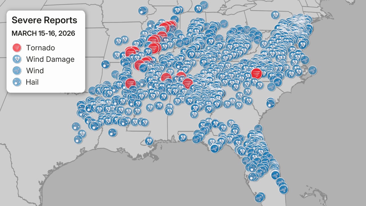
What Happened
Beginning on March 15 and intensifying through March 17, 2026, a powerful low-pressure system collided with record-breaking warmth to create a multi-hazard weather event. In the Midwest, Winter Storm Iona has dropped significant snow totals, with some areas in Wisconsin reporting over 18 inches of accumulation. Meanwhile, the southern edge of the system triggered a severe weather outbreak across the Ohio Valley and into the Mid-Atlantic.

As the storm moved east, it produced damaging wind gusts exceeding 70 mph and multiple confirmed tornado touchdowns in the South and Midwest. Public safety officials have closed major highways in the Midwest due to whiteout conditions caused by high winds reaching 50 mph.
This is a rare and historic setup where we are seeing blizzard conditions in the North and a major tornado threat in the East simultaneously.
Key Developments
Official confirmations from the National Weather Service indicate that the storm system is transitioning into a "bomb cyclone" as it moves toward the Northeast. In Green Bay, Wisconsin, conditions remain life-threatening, with visibility reduced to near zero. For real-time visual updates, you can view the live video report from Green Bay.
Utility companies report that over 250,000 customers are currently without power across five states. In the South, temperatures have reached record highs for March, providing the fuel for the convective storms moving toward the Atlantic coast.
Why This Matters
The scale of this event has significant implications for national logistics and infrastructure. The grounding of flights at major hubs like Chicago O'Hare and Detroit Metropolitan Wayne County Airport has caused a ripple effect in air travel across North America. Factual standings show this could rank as one of the top five most impactful March winter events in the last 50 years for the Great Lakes region.
What Happens Next
The storm system is forecast to move into New England by the morning of March 18, 2026. Residents in the path of the severe line should monitor live updates for emergency alerts. Cold air is expected to surge behind the front, causing a flash freeze on wet roads throughout the Ohio Valley and Northeast.
Key Terms & Concepts
- Bomb Cyclone
- A rapidly intensifying storm caused by a sharp drop in atmospheric pressure over a 24-hour period.
- Blizzard
- A severe snowstorm with winds over 35 mph and visibility reduced to less than 0.25 miles for at least 3 hours.
- Flash Freeze
- A sudden drop in temperature that causes standing water on roads to turn into ice almost instantly.
Frequently Asked Questions
What states are most affected by the blizzard?
Wisconsin and Michigan are facing the brunt of the blizzard, with Green Bay seeing significant snow and 50 mph winds on March 17, 2026.
Is there a tornado risk on the East Coast?
Yes, the National Weather Service has issued severe storm watches for the East Coast, where damaging winds and tornadoes are possible through the evening.
How many people have lost power?
Approximately 250,000 customers across the Midwest and South have lost electricity due to high winds and heavy snow accumulation.
When will the storm end?
The system is expected to clear the East Coast by late March 18, 2026, though a flash freeze may occur as temperatures drop overnight.
Are flights being canceled?
Major airports in Chicago and Detroit have reported significant delays and hundreds of cancellations due to the extreme winter conditions.
Resources
Sources and references cited in this article.