Tropical Cyclone Narelle Intensifies Toward Queensland: Trend Summary
Tropical Cyclone Narelle formed in the Coral Sea and is rapidly strengthening as it barrels toward the Far North Queensland coast, with landfall expected early on Friday, March 20, 2026. Authorities have warned that the system could reach Category 5 intensity, potentially becoming the most powerful cyclone in living memory for the region. Residents from Lockhart River to Port Douglas are currently under a cyclone watch as emergency services begin large-scale evacuations of vulnerable populations.

TL;DR
- Tropical Cyclone Narelle is forecast to strike Far North Queensland as a Category 4 or 5 monster system.
- Landfall is tipped near Coen early Friday morning, with wind gusts potentially exceeding 250 km/h.
- Emergency alerts have been issued for Lockhart River, Coen, and Port Stewart.
- The system may perform a rare triple landfall, crossing into the Northern Territory and Western Australia.
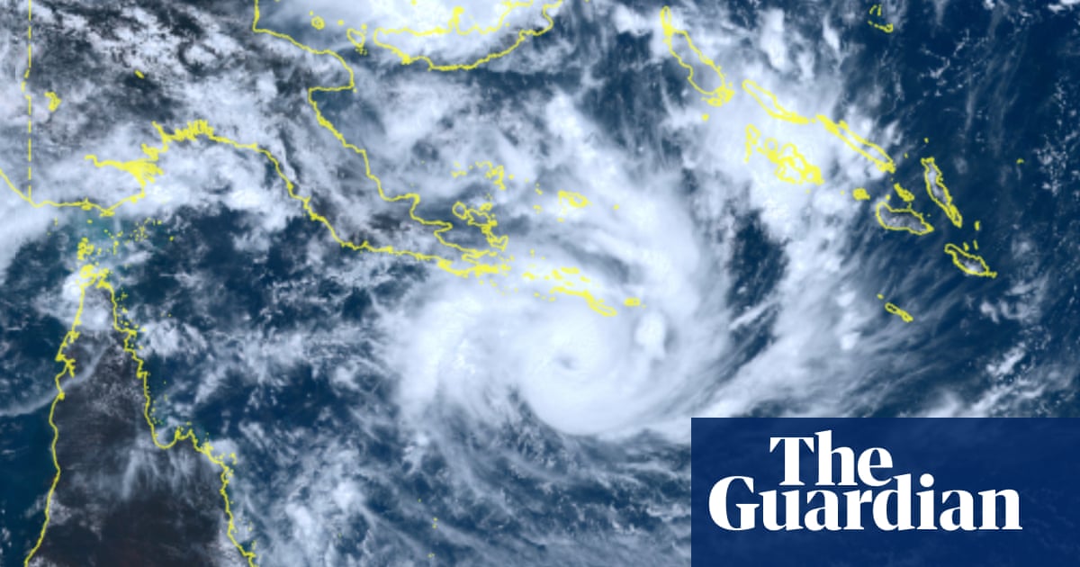
What Happened
Tropical Cyclone Narelle developed from a tropical low south of the Solomon Islands on Tuesday evening and has spent Wednesday intensifying over the warm 29–30°C waters of the Coral Sea. By Wednesday afternoon, the system reached Category 3 strength. The Bureau of Meteorology (BoM) declared a cyclone watch zone spanning 700 km from Lockhart River to Port Douglas. Queensland Premier David Crisafulli confirmed that more than 100 emergency personnel have been deployed to the north to assist with preparations.
Evacuations have already commenced in high-risk areas. The luxury resort on Lizard Island was largely cleared of visitors on Wednesday, leaving only essential staff. Additionally, vulnerable residents, including pregnant women and those requiring dialysis, are being flown out of the projected impact zone to ensure their safety before conditions deteriorate on Thursday.
This may be the biggest system that many people have seen in living memory, and that's why we're asking people to prepare as we have.
Key Developments
The Cook Local Disaster Management Group issued a Cyclone Watch and Act alert for Coen and Port Stewart at 2:14 PM on Wednesday. Meteorologists expect destructive wind gusts up to 155 km/h to begin impacting the coast between Coen and Cooktown by Thursday night. The intense core of the eye is predicted to bring gusts of 225 km/h to 250 km/h upon landfall.
Heavy rainfall is forecast to reach 200mm within 24 hours, creating a high risk of flash flooding in regions like the Daintree River, which are already waterlogged from previous rain events. The Australian Reinsurance Pool Corporation has officially designated Narelle as a Declared Cyclone Event, triggering insurance frameworks for affected policyholders.
Why This Matters
The potential for a Category 5 landfall represents a significant threat to life and infrastructure. Deputy Commissioner Chris Stream warned that debris propelled at 100 km/h or more can be fatal. If Narelle maintains its current trajectory, it could be the first storm in 21 years to make three separate landfalls on the Australian mainland—crossing Cape York, then the Northern Territory's Top End, and finally the Western Australian Kimberley coast. This trajectory mirrors the path of Severe Tropical Cyclone Ingrid in 2005.
A piece of debris being propelled at 100 km or more per hour will likely kill you. This is not the opportunity for you to be outside getting that TikTok moment.
What Happens Next
The window for residents to secure properties is closing, as damaging winds are expected to arrive as early as Thursday morning. After crossing Cape York, the system is forecast to move into the Gulf of Carpentaria on Friday, where it may re-intensify before a second landfall in the Northern Territory on Saturday night. Residents are urged to monitor the Get Ready Queensland portal for evacuation orders and safety checklists.
Key Terms & Concepts
- Category 5 Cyclone
- The most severe cyclone ranking in Australia, involving wind gusts exceeding 280 km/h and extreme destruction.
- Cyclone Watch
- An official notification that a cyclone is expected to impact a region within 48 hours, signaling that residents should begin preparations.
- Storm Tide
- An abnormal rise in sea level caused by a cyclone, which can lead to dangerous coastal flooding when combined with high tides.
Frequently Asked Questions
When will Cyclone Narelle hit Queensland?
Narelle is expected to make landfall near Coen early on the morning of Friday, March 20, 2026. Damaging winds will likely begin impacting the coast by Thursday morning.
Is Narelle a Category 5 cyclone?
Forecasters warn that while it was a Category 3 on Wednesday, it is expected to intensify into a Category 4 or 5 monster system before crossing the coast.
What areas are in the direct path of the storm?
The primary watch zone stretches from Lockhart River to Port Douglas. Communities like Coen and Cooktown are tipped for the most destructive impacts.
Why is this cyclone called a "triple-hit" system?
Meteorologists believe Narelle could make three separate landfalls: first in Queensland, followed by the Northern Territory, and potentially Western Australia.
What should residents do right now?
Locals should secure loose items, stock emergency kits, and follow evacuation advice immediately. Authorities emphasize that the window to act will close by Thursday evening.

Resources
Sources and references cited in this article.