
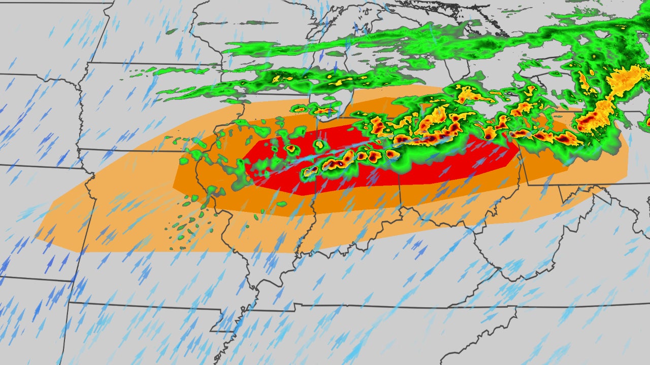
Latest Developments: Severe Thunderstorm Watch Issued Across Midwest and Miami Valley
The National Weather Service has issued severe thunderstorm watches and warnings across the Midwest, specifically targeting the Chicago area and the Miami Valley, throughout Thursday, March 26, 2026. These atmospheric conditions are producing large hail, damaging winds, and the potential for isolated tornadoes as a cold front moves through the region. The immediate impact includes the mobilization of utility crews and potential disruptions to major public events, including the Chicago Cubs home opener.
Key Points
- Outcome: Severe storms are currently racing toward the Chicago area with the primary threat concentrated south of the city.
- Action: Utility companies like AEP Ohio and emergency management agencies in Franklin County have mobilized crews to address potential power outages.
- Impact: Weather conditions at Wrigley Field suggest hail reaching sizes nearly as large as a baseball, threatening the Cubs home opener.
- Why it Matters: The combination of 60-70 mph wind gusts and large hail poses a significant risk to homes, vehicles, and power infrastructure.
What Happened
The storm system began intensifying early Thursday, prompting local meteorologists to declare a Weather Alert Day for Michigan and Ohio. In Chicago, the threat evolved rapidly as storms began moving through the metro area during the afternoon hours, carrying the risk of significant property damage.

Key Developments
New reports indicate that the Miami Valley is bracing for the strongest surge of the system tonight. Safety experts from AAA have advised residents to secure outdoor furniture and park vehicles in garages to avoid hail damage. For real-time updates on local conditions and power status, residents can monitor the FOX 32 Live Update Portal. Emergency management officials emphasized that despite the speed of the storms, the window for dangerous activity remains open until late evening.
Why This Matters
The severity of this particular system lies in its dual-threat nature of wind and ice. Large hail can penetrate roofing and shatter windshields, while saturated ground from previous rains increases the likelihood of trees falling onto power lines.

What Happens Next
The cold front is expected to push through the Miami Valley by Friday morning, leading to a significant drop in temperatures. Utility crews will remain on 24-hour standby through the night to restore service to any affected grids. Major league officials will monitor the hail threat at Wrigley Field to determine if the game can proceed as scheduled or requires a delay for fan safety.
Key Terms
- Severe Thunderstorm Watch
- An alert indicating that weather conditions are favorable for the development of severe storms in and close to the watch area.
- Base-ball Sized Hail
- Atmospheric ice reaching approximately 2.75 inches in diameter, capable of causing extreme structural damage.
FAQ
What is the biggest threat for the Chicago area?
The primary concerns are damaging winds and very large hail, particularly south of the city center. Some storm cells have the potential to produce hail the size of baseballs near Wrigley Field.
How are utility companies preparing for the storm?
Companies like AEP Ohio have pre-positioned repair crews and equipment in high-risk zones. They are working in coordination with Franklin County Emergency Management to respond to downed lines.
Will the Cubs home opener be canceled?
Currently, the game remains scheduled, but officials are closely monitoring the live weather updates. A final decision will depend on the timing of hail and lightning strikes near the stadium.
When will the severe weather end in the Miami Valley?
Strong to severe storms are expected to persist throughout the night. Conditions are projected to stabilize by Friday morning as the cold front moves east.

Resources
Sources and references cited in this article.