
New York City's longest dry stretch of 2026 is coming to an end, with rain expected to return Thursday before a potentially much wetter Friday. While the city itself is forecast to receive around half an inch of rain, coastal communities east of New York City could experience totals exceeding two inches. The main uncertainty is where a concentrated band of heavy rain will develop as a cold front moves along the East Coast.
What Is Happening
A prolonged period of unusually dry and warm weather across the New York metropolitan area is ending as an approaching cold front brings showers and heavier rainfall.
According to NBC New York's Storm Team 4, scattered showers will begin arriving Thursday morning. These initial showers should remain relatively light and intermittent rather than producing continuous rainfall throughout the day.
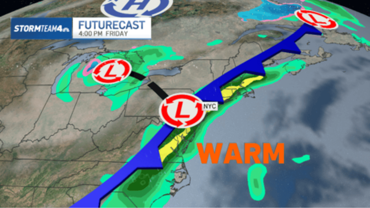
The more significant change is expected Thursday night into Friday. A cold front moving along the East Coast will interact with a concentrated area of atmospheric moisture, producing periods of heavier rain and potentially embedded thunderstorms near the immediate coast.
The returning rainfall follows the region's longest dry stretch of the year. Although the precipitation will provide relief from dry conditions, concentrated downpours could create localized flooding problems.
Where and When
The forecast divides the New York metropolitan area into areas with noticeably different rainfall expectations.
- Thursday morning: Scattered, generally light showers begin moving into the region.
- Thursday afternoon and evening: Additional showers are possible as the approaching weather system develops.
- Friday morning: Steadier rainfall is expected, with heavier showers and possible thunderstorms near the immediate coast.
- Friday afternoon and evening: Periods of rain may continue as the cold front moves through.
- Saturday morning: Rain should gradually move away, with drier conditions developing behind the front.
New York City is expected to receive approximately half an inch of rain. Staten Island and other parts of the metropolitan area should experience similar conditions, although the heaviest rainfall could shift depending on the storm's track.
Long Island and the Jersey Shore face a potentially wetter scenario. One forecast model suggests these coastal locations could receive two to three inches or more, while another keeps the heaviest precipitation offshore.

Expected Impacts
The biggest immediate concern is localized flooding, particularly in coastal communities that receive repeated rounds of heavy rainfall.
Staten Island could experience more substantial precipitation than the rest of New York City if the heavier rain band shifts eastward. However, the current forecast suggests that rainfall should spread over several hours, reducing the likelihood of widespread flooding.
There are several potential effects residents should consider:
- Road conditions: Heavy showers can produce standing water and temporarily difficult driving conditions.
- Localized flooding: Low-lying streets and areas with poor drainage could experience water accumulation.
- Coastal communities: Long Island and the Jersey Shore could receive considerably higher rainfall totals than inland locations.
- Outdoor activities: Friday's unsettled weather could disrupt commuting, outdoor events and other planned activities.
The return of rain will also mark a noticeable temperature change. Thursday's unusually mild conditions are expected to give way to cooler weather behind the cold front.
Official Advice
Residents should prepare for changing weather conditions, particularly if traveling Friday morning or afternoon. NBC New York recommends carrying an umbrella on Thursday, while the Staten Island forecast advises residents to remain alert for possible local impacts.
Practical precautions include:
- Carry an umbrella and waterproof outerwear when leaving home.
- Allow additional travel time during periods of heavier rainfall.
- Pay attention to changing road conditions and avoid driving through standing floodwater.
- Monitor National Weather Service updates for any flood or thunderstorm alerts affecting your location.
No severe weather is currently anticipated in the NBC New York forecast, although isolated flooding remains possible. Residents should distinguish between the absence of an expected severe-weather outbreak and the possibility of localized flooding during heavy downpours.
What Forecasters Are Watching
The most important forecasting question is the precise position of the heavy rainfall band on Friday.
NBC New York identifies a significant difference between two major forecast models. The American model places the heavier rain close enough to affect Long Island and the Jersey Shore, potentially producing two to three inches or more. The European model moves the heaviest precipitation offshore, resulting in substantially lower totals across the region.
This difference matters because the boundary between heavier and lighter rainfall could be relatively sharp. A small eastward shift in the cold front could move much of the heaviest precipitation away from coastal communities. A different track could produce considerably wetter conditions.
Forecasters are also monitoring the timing of the system's departure. The expected arrival of drier air behind the front should improve conditions by Saturday morning, although lingering showers remain possible.
For New Yorkers, Friday is the day requiring the most attention. The city is not currently expected to experience widespread severe weather, but localized downpours and changing coastal rainfall forecasts make checking updated weather information worthwhile.
Frequently Asked Questions
When will it rain in NYC this week?
Scattered showers are expected Thursday, November 5, with steadier and potentially heavier rainfall arriving Thursday night and continuing through Friday, November 6.
How much rain will New York City receive?
Approximately half an inch is expected across much of the New York City metropolitan area, although totals could change with the position of the heaviest rain band.
Will Long Island experience flooding on Friday?
Localized flooding is possible if heavier rainfall reaches Long Island. Some forecasts suggest two to three inches or more, but the heaviest rain could remain offshore.
Will NYC experience severe thunderstorms?
Severe weather is not currently anticipated in the NBC New York forecast. However, embedded thunderstorms and isolated flooding remain possible Friday.
When will the rain stop in New York?
Significant rainfall should taper off Friday night, with lingering showers expected to move away by Saturday morning, November 7.