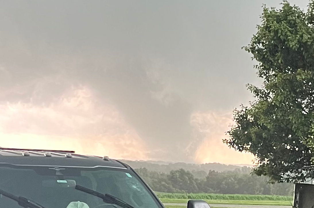
What’s behind Kansas City’s 80 mph storm damage?
By Saturday night, roads in Johnson County were blocked by snapped limbs, uprooted trees and crews racing from one hazard call to the next. The storm’s winds hit speeds normally associated with a minor tornado, even though the damage came from severe thunderstorm winds. Official stations reported gusts up to 80 mph in parts of the Kansas City metro, while Johnson County’s emergency dispatch system was overloaded for about 40 minutes.
How Events Unfolded
The first severe thunderstorm warning for Johnson County was issued at 8 p.m. Saturday, warning of possible wind gusts up to 70 mph and quarter-size hail, according to the Johnson County Post report. Less than 10 minutes later, the warning was upgraded to include “destructive winds,” a National Weather Service category that can reach 80 mph.
The numbers were not abstract. The Olathe Executive Airport station recorded a peak gust of 71 mph. Kansas City Downtown Airport recorded 77 mph, while Bonner Springs also logged 71 mph. For residents, that meant trees came down fast enough to shut streets before crews could clear them.
In Merriam, a large maple tree in front of 5936 Goodman St. fell east across the road and landed on a street light pole, snapping it near the base. Prairie Village saw two trees lose large limbs in the 6700 block of Delmar Lane, also blocking traffic.
Between 8:30 and 10 p.m., online call logs showed officers from Mission Hills to Gardner responding to nearly 20 calls involving trees and debris that created traffic hazards.
Critical Details
The storm was part of a larger early June pattern across the central United States. KQ2 reported that Kansas, Missouri, Iowa and Nebraska had already seen three severe-weather episodes in one week, with tornadoes, damaging winds, large hail and flooding affecting different parts of the region.

That setup matters because repeated storms can compound the damage. Earlier in the week, storms produced 90 to 100 mph gusts in Salina, Kansas, with the highest report measured at 113 mph. Even after weakening, the storms still produced 60 to 80 mph gusts and flash flooding from Topeka to the west side of Kansas City.
ABC17NEWS described a separate severe setup driven by low pressure redeveloping to the west, a boundary lifting northwest and a cold front arriving late in the day. That combination allowed instability to rebuild, giving storms a stronger environment once they formed. In plain English: warm, unstable air and enough wind shear can turn afternoon storms into damaging evening storms.
- Destructive winds
- A National Weather Service warning term for thunderstorm winds that can reach up to 80 mph.
- Straight-line winds
- Damaging thunderstorm winds that are not caused by a tornado but can still topple trees and damage structures.
- System overload
- A dispatch condition when calls arrive faster than emergency dispatchers can send them out over the radio.
Reactions & Responses
The Johnson County Emergency Communications Center, which handles call-taking and dispatching for all county fire departments and Med-Act, went into system overload at about 9 p.m.. In that mode, each fire department assigns an overload officer to track incoming calls and assign crews, freeing dispatchers to answer emergency calls and manage essential radio traffic.
The overload was canceled at 9:40 p.m. as emergency call volume returned closer to normal and departments cleared the backup of calls for service. No immediate storm-related injuries or significant structural damage were reported in Johnson County.
Other parts of the region were also under threat. KMAland reported a Severe Thunderstorm Warning for southeastern Atchison County and west central Nodaway County in Missouri, with hazards of 60 mph wind gusts and quarter-size hail. The warning cited expected hail damage to vehicles and wind damage to roofs, siding and trees.
Putting It in Perspective
For Kansas City-area residents, the key takeaway is that severe thunderstorm winds can do tornado-like damage without a tornado ever touching down. An 80 mph gust is strong enough to uproot trees, block roads and overwhelm local emergency systems when many calls happen at once.

The week’s pattern also shows why the Midwest can face several different hazards from one unsettled stretch: hail in one corridor, tornado reports in another, flooding where heavy rain repeats and wind damage where storms organize into fast-moving lines. KQ2 reported that some counties picked up 4 to 7 inches of rain by Thursday morning, after an estimated 12 to 20 inches over the prior 30 days.
That much rain leaves soils saturated, making trees more vulnerable when strong winds arrive. The result is a chain reaction: wet ground weakens root support, severe gusts bring limbs down, roads close, and dispatchers suddenly face a rush of hazard calls.
Looking Ahead
What is confirmed is the damage picture from Johnson County: multiple blocked roads, nearly 20 traffic-hazard calls, a dispatch overload that lasted from about 9 p.m. to 9:40 p.m., and no immediate reports of injuries or major structural damage.
Across the region, forecasters and local outlets continued tracking severe storm threats tied to cold fronts, instability and wind shear. For residents, the practical step is simple: treat severe thunderstorm warnings seriously, especially when they mention destructive winds, hail or tornado potential.
FAQ
How strong were the winds in the Kansas City storm?
Official observation stations reported gusts up to 80 mph in parts of the Kansas City metro. Kansas City Downtown Airport recorded 77 mph, and Olathe Executive Airport recorded 71 mph.
Did Johnson County report injuries from the storm?
No immediate storm-related injuries or significant structural damage were reported in Johnson County, according to the Johnson County Post.
Why did emergency dispatchers go into system overload?
The Johnson County Emergency Communications Center entered system overload at about 9 p.m. because calls were coming in faster than dispatchers could send them out over the radio.
What areas saw tree damage in Johnson County?
Merriam and Prairie Village were among the reported damage spots. A large maple tree blocked Goodman Street in Merriam, and large limbs blocked Delmar Lane in Prairie Village.
What makes 80 mph thunderstorm winds dangerous?
They can match the wind speed of an EF-0 tornado, which is strong enough to topple trees, damage power infrastructure and block roads quickly.

Resources
Sources and references cited in this article.