
Last updated: June 16, 2026, 12:58 PM EDT
What's behind the Tropical Storm Watch on the Gulf Coast?
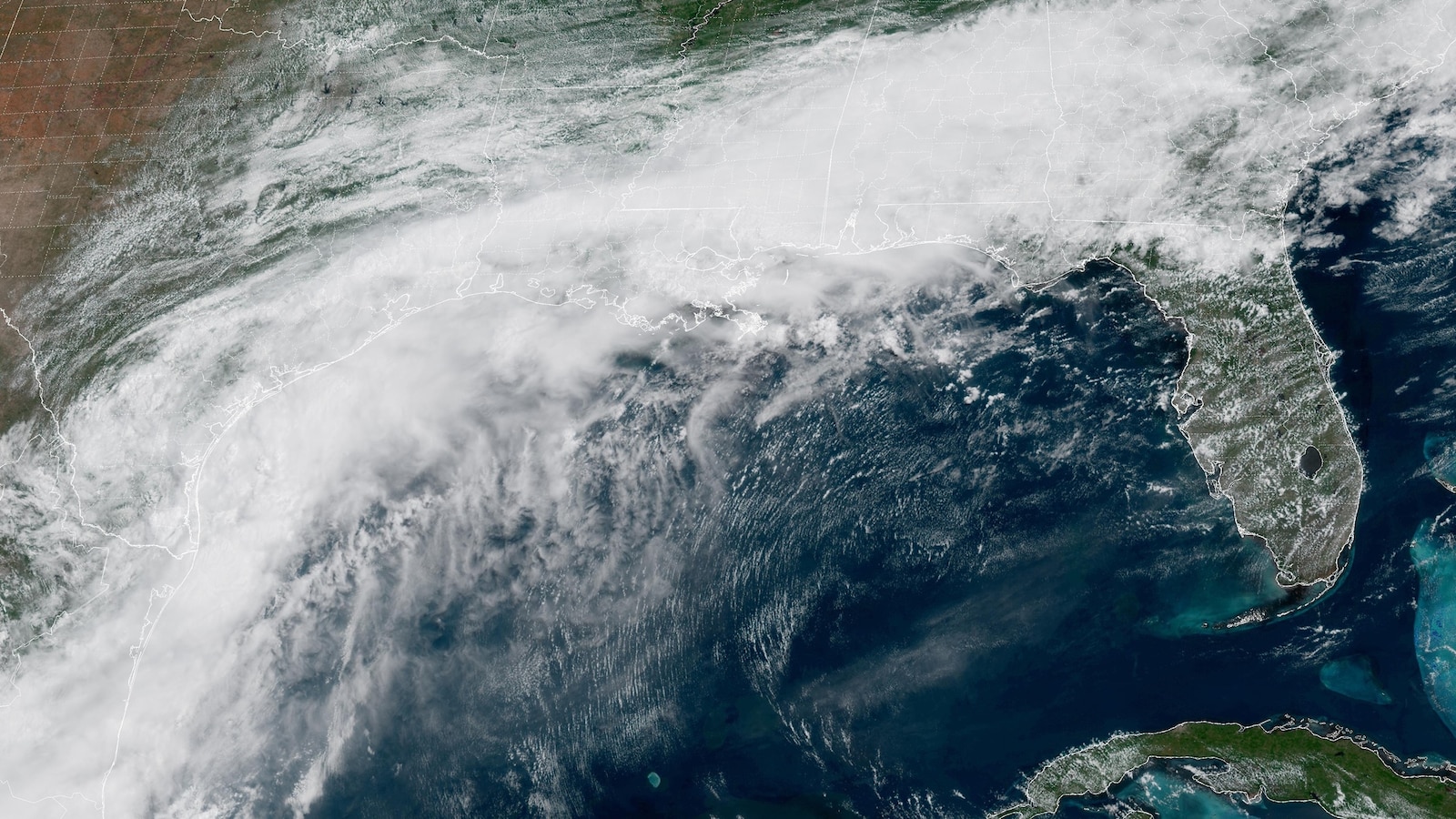
Potential Tropical Cyclone One was near South Texas on Tuesday, June 16, 2026, as the National Hurricane Center issued a Tropical Storm Watch from Sargent, Texas, to Morgan City, Louisiana.
The system could become Tropical Storm Arthur late Tuesday or early Wednesday, but the biggest danger is not the name on the map. Heavy rain, flash flooding, gusty coastal winds and storm surge are already putting millions across Texas, Louisiana, Mississippi and nearby Gulf Coast communities on alert.

The Full Story
The National Hurricane Center began advisories on Potential Tropical Cyclone One at 11 a.m. Tuesday after a messy low-pressure system over South Texas showed enough threat to trigger coastal alerts. FOX 13 Tampa Bay reported the system was near 27 degrees north latitude and 98 degrees west longitude, moving northeast at 6 mph with sustained winds of 30 mph.
The disturbance has a short window to organize over the northwestern Gulf. FOX 13 meteorologist Jim Weber said it could move over Gulf waters Tuesday night or Wednesday morning and become Tropical Storm Arthur before coming ashore somewhere between Texas and Louisiana. ABC News reported that a hurricane is not expected under the latest forecast.

Rain is already the headline hazard. Click2Houston warned that rainfall rates could exceed 2 to 4 inches per hour, fast enough to overwhelm drainage and cause flash flooding with little warning. FOX Weather reported radar estimates of more than 5 inches in three hours in parts of Montgomery and northern Harris counties, including The Woodlands.
The watch zone stretches from Sargent, Texas, to Morgan City, Louisiana, meaning tropical-storm-force conditions are possible in the next day or so. ABC News said the watch covers southeast Texas, including Brazosport, Galveston and Port Arthur, and parts of southwestern Louisiana. Along the coast, winds could gust over 40 mph, and water may rise enough to flood low-lying areas.
The Main Players
The National Hurricane Center is the lead forecasting agency on the system, issuing advisories, watches and warnings as the low-pressure area tries to organize. Its Potential Tropical Cyclone label lets forecasters issue alerts before the storm has a fully formed center.
Local meteorologists and emergency managers are focused less on whether the storm gets the name Arthur and more on where the rain bands stall. FOX 13 meteorologist Jim Weber described the system as likely to move northeast toward a Texas-Louisiana landfall. Click2Houston focused its guidance on Houston-area street flooding, drainage impacts and the danger of driving through flooded roads.
Emergency officials are already responding to flood impacts. ABC News reported that a woman in Bandera County, northwest of San Antonio, called 911 Monday morning saying her car was being swept into a creek by floodwaters; hours later she was found dead in the vehicle several miles downstream. The same report cited stalled vehicles in San Antonio, Houston and Waco, water rescues in Shreveport, Louisiana, and impassable roads at Kessler Air Force Base.
- Potential Tropical Cyclone
- A system that has not fully become a tropical depression or storm, but can still bring tropical-storm-force winds to land and needs watches or warnings.
- Tropical Storm Watch
- An alert meaning sustained winds of 40 mph or greater are possible in the watch area.
- Storm surge
- An abnormal rise of water pushed toward shore by a storm, on top of normal tides.
Key Statistics
The numbers show why forecasters are treating this as a serious water event even without a hurricane forecast. Potential Tropical Cyclone One had sustained winds of 30 mph, which is 9 to 10 mph below tropical storm strength depending on how thresholds are rounded in reports. The system had a 60% chance of formation within 48 hours and within seven days, according to Live 5 News and The Washington Post.
Rainfall projections vary by location. Live 5 News reported expected totals of 4 to 8 inches in impacted areas, with isolated amounts up to 12 inches. Click2Houston said most of Southeast Texas could receive 4 to 7 inches through the end of the week, with localized amounts of 10 to 15 inches or more where the heaviest rain repeats.
ABC News reported that more than 17 million Americans remained under flood watches from Texas to Mississippi on Tuesday. Storm surge could reach 2 to 4 feet along parts of the coast, while Space City Weather placed Houston under a Stage 2 flood alert and said coastal water levels could run 1 to 3 feet above normal tides.
What This Means
For Gulf Coast residents, the practical message is simple: this is a flood-first storm. A named storm would get attention, but repeated tropical downpours over the same roads, bayous and neighborhoods can cause the most dangerous outcomes.
That matters especially in metro areas like Houston, where heavy rain can overwhelm drainage quickly. Space City Weather said the Houston area could see widespread showers and storms Tuesday, especially south of I-10, with 2 to 4 inches possible and isolated 6-inch totals. Its forecast also said the later-week flood risk for Houston was trending lower if the system stays far enough offshore.
For people outside Texas, the risk spreads east. The Washington Post said the disturbance will soon drench a stretch from eastern Texas to the Carolinas, while ABC News noted New Orleans could see very heavy rain as early as Wednesday evening or as late as Thursday morning, depending on how fast the storm develops.
What to Expect
Potential Tropical Cyclone One is forecast to move from South Texas toward the northwestern Gulf, where it may briefly organize before making landfall near the Texas-Louisiana border area. If it becomes a tropical storm, it will be named Arthur, the first named storm of the 2026 Atlantic hurricane season.
The next confirmed hazards are heavy rainfall, flash flooding, minor to moderate coastal flooding, gusty winds and rough surf along parts of the Texas and Louisiana coast. Flood threat areas shift eastward through the week, with ABC News listing a level 3 of 4 flood threat Wednesday for Houston, Beaumont, Lake Charles and Lafayette, then Thursday from Baton Rouge through Jackson, Montgomery and Birmingham.
Residents in watch and flood-prone areas should follow local National Weather Service and emergency management instructions, avoid flooded roads and secure loose outdoor items before stronger rain bands and gusty winds arrive.
FAQ
Where is the Tropical Storm Watch in effect?
The Tropical Storm Watch is in effect from Sargent, Texas, to Morgan City, Louisiana, including parts of southeast Texas and southwestern Louisiana.
Could Potential Tropical Cyclone One become Tropical Storm Arthur?
Yes. The system could become Tropical Storm Arthur late Tuesday or early Wednesday if it strengthens and organizes over the Gulf.
Is a hurricane expected from this Gulf system?
No. ABC News reported that a hurricane is not expected under the latest forecast.
How much rain could fall from Potential Tropical Cyclone One?
Forecasts call for widespread totals of 4 to 8 inches in impacted areas, with isolated totals up to 12 inches or more. Southeast Texas could see localized totals of 10 to 15 inches where rain bands repeat.
What is the biggest danger from this system?
The biggest danger is flooding from heavy tropical rain. Gusty winds, storm surge and coastal flooding are also expected along parts of the Gulf Coast.

Resources
Sources and references cited in this article.