
Last updated: July 27, 2026, evening EDT
For readers in the United States, Hurricane Genevieve is a powerful Pacific storm worth tracking, but its forecast path currently keeps it far from the U.S. mainland and Hawaii. Genevieve briefly reached Category 5 strength early Monday before easing back to Category 4, with sustained winds still measured near the top of that range. Forecasts keep the center moving northwest over open water, roughly parallel to Mexico's Pacific coast, while dangerous surf and rip currents affect parts of southwestern Mexico and the Baja California Peninsula.
The Story at a Glance
Genevieve formed south of Mexico and intensified with unusual speed. It rose from a tropical depression on Friday, July 24, to a Category 5 hurricane by 5 a.m. EDT on Monday, July 27, when sustained winds reached 160 mph and central pressure fell to 925 millibars. By late Monday, the storm had weakened somewhat, with one National Hurricane Center update placing winds at 145 mph and the center about 505 miles southwest of the southern tip of Baja California.
No coastal watches or warnings were in effect for Genevieve. The latest track described by AP's storm report keeps the hurricane well offshore on a west-northwest to northwest course. The main verified land-related hazard is ocean swell, which can produce life-threatening surf and rip currents along Mexico's southwestern coast and southern Baja California.
How the Story Developed
Genevieve was first identified as a tropical storm about 570 miles south of Zihuatanejo, Mexico, with winds near 50 mph. Forecasters warned at that stage that rapid intensification was likely. The storm then strengthened into a Category 4 hurricane southwest of Manzanillo, with winds of 140 mph, before reaching Category 5 strength within roughly 24 hours of being named.
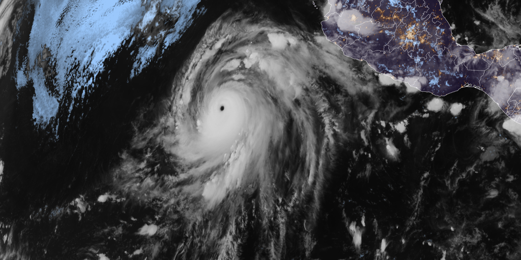
The rapid strengthening was supported by very warm water, a moist atmosphere and limited disruptive winds aloft. Yale Climate Connections reported sea-surface temperatures around 86 degrees Fahrenheit and relative humidity above 80% near the storm. The hurricane is expected to weaken as it reaches cooler water below about 77 degrees Fahrenheit and drier air later in the week.
The Genevieve tracking map shows why forecasters continue to monitor changes even with the storm far offshore: Pacific systems usually move west, but shifts in steering patterns can sometimes turn them toward Baja California or Mexico. The current forecast does not show that turn.
Key People and Details
The National Hurricane Center in Miami is the primary forecasting authority cited across the reports. Its advisories place Genevieve on a course that stays clear of land during the five-day forecast period, with a slight leftward bend expected to carry the storm even farther offshore.

Genevieve is the seventh named storm of the 2026 Eastern Pacific season and the first storm in that basin to reach Category 5 strength since Hurricane Kristy in 2024. It also became the Northern Hemisphere's first major hurricane of the 2026 season across the Atlantic and Eastern Pacific basins, according to FOX Weather.
- Major hurricane
- A Category 3 storm or higher, with winds of at least 111 mph, according to the National Hurricane Center description cited by AP.
- Rapid intensification
- Genevieve's climb from a tropical depression on Friday to Category 5 strength on Monday.
- Rip-current conditions
- The dangerous coastal currents associated with Genevieve's swells even while the storm's center stays offshore.
For U.S. readers, one detail prevents confusion: Genevieve is not the storm closest to Hawaii. Fausto, a separate weakening tropical storm, was moving west-northwest north of the islands and generating large surf and strong currents along east-facing shores.
Reaction and Response
Officials had not issued coastal watches or warnings for Genevieve because the center was forecast to remain far from land. Advisories instead focused on marine hazards. Swells were already affecting Mexico's southwestern coast and the Baja California Peninsula, where beachgoers and boaters face the most immediate risk.
Forecasters also emphasized continued monitoring rather than evacuation or landfall preparations. The storm's intensity may fluctuate before the expected weakening begins, but the track guidance reported by Yale Climate Connections keeps the system away from populated areas over the next five days.
What to Watch
The next key question is how quickly Genevieve weakens as it crosses cooler water and enters drier air. Forecasts indicate it could fall below hurricane strength around Friday and become a weak system or dissipate by the weekend.
Track changes remain the other point to follow. The present path bends farther from land, but updated National Hurricane Center advisories will show whether the center maintains that course. Residents and travelers along Mexico's Pacific coast should also watch local surf guidance because dangerous rip currents can persist even while the hurricane's center remains hundreds of miles offshore.
Frequently Asked Questions
Where is Hurricane Genevieve headed?
Genevieve is moving northwest over the eastern Pacific, roughly parallel to Mexico's coast, with forecasts keeping it well offshore.
Will Hurricane Genevieve hit the United States?
No U.S. landfall is shown in the reported forecast. The storm is far from the mainland and is not the system passing near Hawaii.
How strong did Genevieve become?
Genevieve briefly reached Category 5 strength with sustained winds of 160 mph before weakening back to Category 4.
Why did Genevieve intensify so quickly?
Very warm water, high atmospheric moisture and relatively low wind shear gave the storm favorable conditions for rapid strengthening.
What hazards are affecting land?
Large swells are producing life-threatening surf and rip-current conditions along parts of southwestern Mexico and the Baja California Peninsula.